Map Set Organization and Sheet Identification
Topographic quadrangle maps typically are published in sets that cover defined geopolitical areas in a predictable, gridded pattern. Grid systems can be universal,national, or local or they may be created and used only for a specific map set. Each individual map within a set has a unique identifier that may be comprised of numbers, letters, numbers and letters, or a name that has significance in the area covered.
Map sheets in sets can be identified using an index map. Index maps show all of the individual maps within a set, overlaid onto the larger geographical area that the set covers. It is usually necessary to consult the index map in order to find the sheet number or name of the topographic quadrangles needed.
The Map Library holds the index maps for most of its series in a file cabinet near the circulation desk in call number order. Please ask at the desk for assistance in locating and retrieving an individual map from a map series.
Scale
Scale is the ratio of the distance on the map to the actual distance on the Earth’s surface. A map of scale 1:24,000 means that one inch on the map is equivalent to 24,000 inches on the ground.
Scale can be an important factor in determining if a particular topographic map or map set will be useful. Topographic maps are created at a wide variety of scale with related degrees of detail and generalization. Small-scale maps show less detail; large-scale maps show more detail. If small-scale and large-scale maps centered on the same location were printed on paper of the same size, the small-scale map would show more geographical area than the large-scale map.
1:24,000-scale maps are large scale, while 1:1,000,000-scale maps are small scale. In order to make sense of large versus small scale maps, it may be helpful to think of the ratio (e.g. 1:24,000 or 1:1,000,000) as a fraction or division problem. The larger the value of the fraction or quotient, the larger the scale (e.g. 1/24,000 is larger than 1/1,000,000).


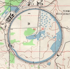
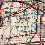
Of the three maps of Fermi National Accelerator (above), the map at 1:24,000-scale is at the largest scale and shows the greatest amount of detail while the map at 1:250,000-scale is the smallest of the three and shows the least amount of detail.